The New Notion Club Archives
About
Community
Community Corner
'''Welcome to The New Notion Club Archives!''' The Community Portal is where this wiki community comes together to organize and discuss projects for the wiki. To see the most recent discussions, click the '''Discussion''' tab above.
You can find out more general information about the wiki on the [[Project:About|About]] page.
Also check out [[The New Notion Club Archives:Wiki to-do list]] for wiki-wide items, and [[Needs to be done]] for content-related items.
==New to wikis?==
* If you are new to wikis, you may want to read the '''[[Wikia:Help:Tutorial 1|tutorial]]''' on the Central Wikia.
* There is some advice on getting this wiki started at '''[[Help:Starting this wiki]]'''.
* A list of most help pages can be found in '''[[:Category:Help]]'''.
==How to help out==
* If you want to help but you're not sure where to start, try improving the various '''[[:Category:Article stubs|stub]]''' articles by adding content.
* Another helpful activity would be to check the list of '''[[Special:Wantedpages|wanted pages]]''' for frequently linked-to articles that don't exist yet.
* To follow the changes to this wiki, and to look out for new users and edits use '''[[Special:Recentchanges|recent changes]]'''.
* You can find a list of useful templates on '''[[:Category:Templates]]''', some of which are documented on '''[[The New Notion Club Archives:Templates]]'''.
* If you need help editing, you could start with '''[[Help:Editing]]''' or '''[[Wikia:Help:Tutorial 1|the tutorial]] on the Central Wikia'''.
==Want to discuss stuff?==
* If you want to discuss anything specific to an article, you can use '''[[Help:Talk page|the talk page]]''' for that article.
* For more general discussions you can use the Discussion tab of this page, or a Forum if the forums have been set up.
==Things to do==
{| class="" style="background-color:transparent; color:inherit; width:100%"
| width="50%" align="left" valign="top" |
; Useful activities
* Help expand some '''[[:Category:Article stubs|article stubs]]'''.
* '''[[Special:Shortpages|Locate]]''' and '''[[Template:Stub|mark]]''' pages that need expanding as [[:Category:Article stubs|article stubs]].
* Create links to some '''[[Special:Lonelypages|orphaned pages]]'''.
* Upload and add some images! Visit '''[[Special:Upload]]'''. Add them to a category too, like [[[[:Category:Images]]]].
* Write a new article that's on the '''[[Special:Wantedpages|the wanted list]]'''!
* Fix any '''[[Special:Doubleredirects|double redirects]]''' by redirecting the first page to the third page.
* Check for '''[[Special:Brokenredirects|broken redirects]]''' and either mark them for deletion or find a more appropriate target.
* Consider splitting up very '''[[Special:Longpages|long pages]]''' into different pages or subpages.
* Create some links on '''[[Special:Deadendpages|dead end pages]]'''.
* ''Add more...''
| width="50%" align="left" valign="top" |
; Other useful special pages
*[[Special:BrokenRedirects]]
*[[Special:DoubleRedirects]]
*[[Special:ProblemReports]]
*[[Special:Uncategorizedcategories]]
*[[Special:Uncategorizedimages]]
*[[Special:Uncategorizedpages]]
*[[Special:Unusedimages]]
*[[Special:Wantedcategories]]
*'''Check out the full list of special pages at [[Special:Specialpages]].'''
|}
==Some other interesting pages==
* Want to find out what you've done so far? Visit [[Special:Mycontributions|your contributions page]].
* Find out more about the wiki on '''[[Special:Statistics]]''' and '''[[Special:Version]]'''!
[[Category:Help]][[Category:Community]]
Wiki to-do list
Content items needs-to-be-done
Forum
Policy
Administrators
New Articles
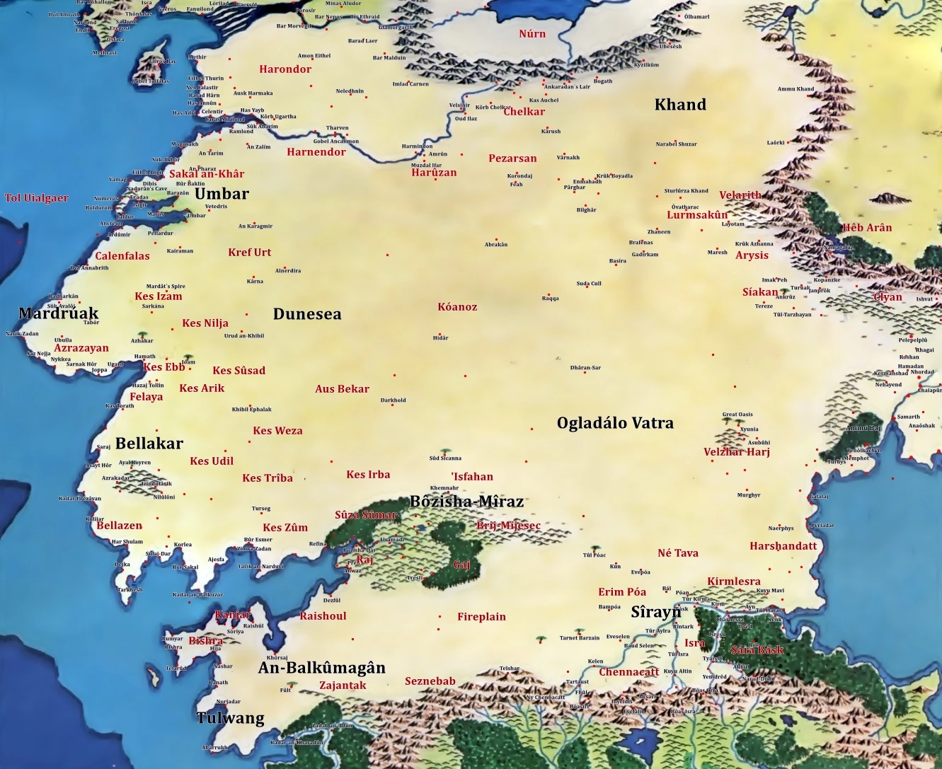
Harad - Globe
Haradwaith
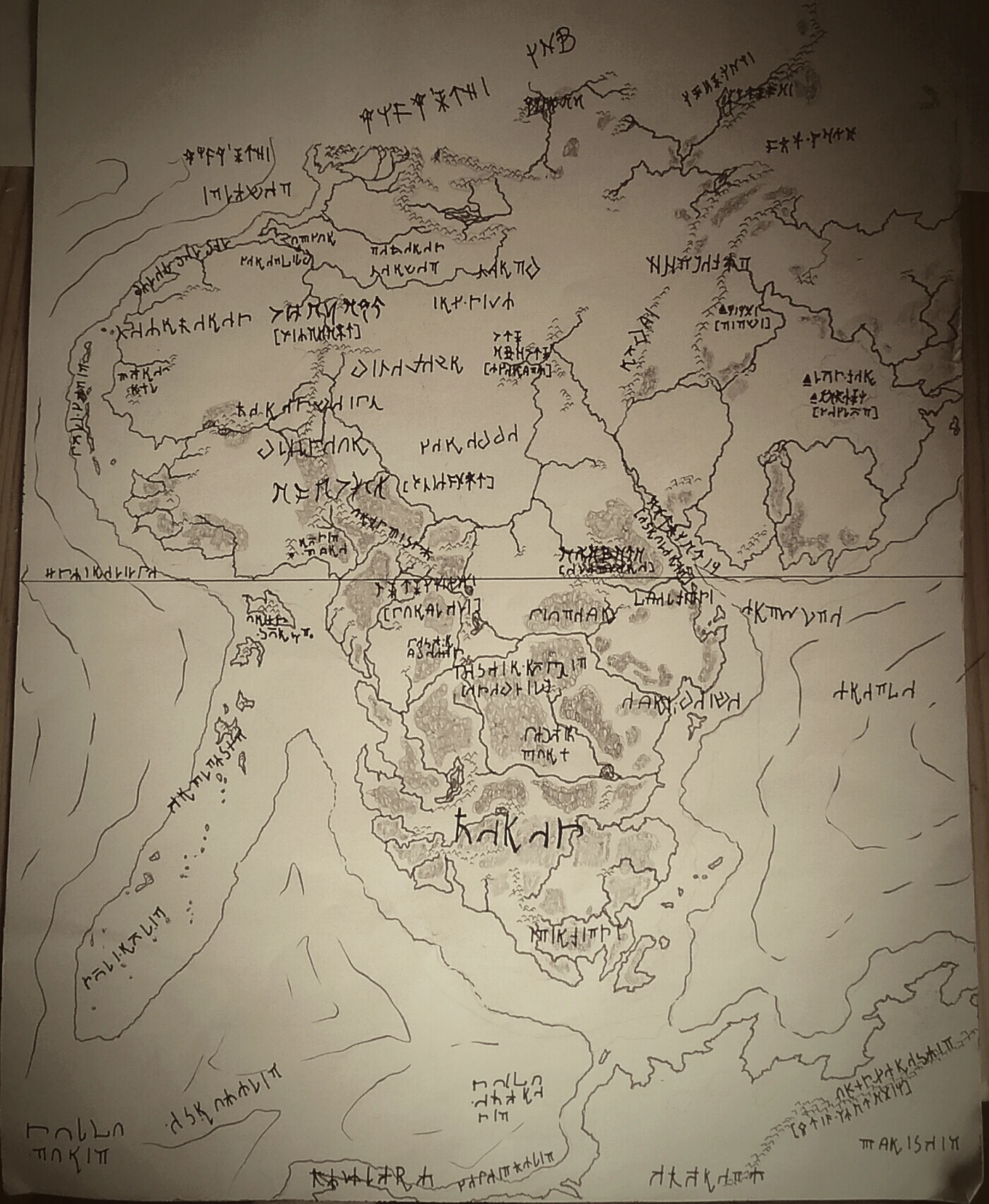
Indigenous map
Type : desert waste; savannah, rainforest.Area : 11.500,000+ square miles.Elevation : average: 500 feet.lowest point: sea level.
highest point: Nakal Jofir (Apy. "The Camel's Back"): 4.980 feet.
Climate : average annual precipitation: 5-15 inches.mean annual temperature: 70-80°F
average low: Narwain 45°F
average high: Urui 125°F
Location : The average Gondorian named any place south of the river Poros "Harad." A more scholarly use of the term referred to those lands bounded by the Harnen River and the Ephel Dúath in the north, the Belegaer on the west, the Ered Harmal to the east, and the Yellow Mountains in the south.Composition : The blasted, unfriendly land of Harad conjured images of rolling sand dunes in the minds of most Gondorians, but dunes constituted only a small portion of the total area of its vast desert. Most of the Haradwaith was made up of exposed layers of sedimentary rock, eroded by countless centuries of wind. Sandstone and limestone predominate, with conglomerate common in the many dry stream and river beds. Iron and copper ores could be found near the coast. Dry salt lakes were a valuable resource for anyone able to carry tons of block salt across the desert. Legends in Umbar spoke of a gold mine at an oasis in the middle of the desert , but such stories were probably based on dreams rather than fact.See also [ ]


