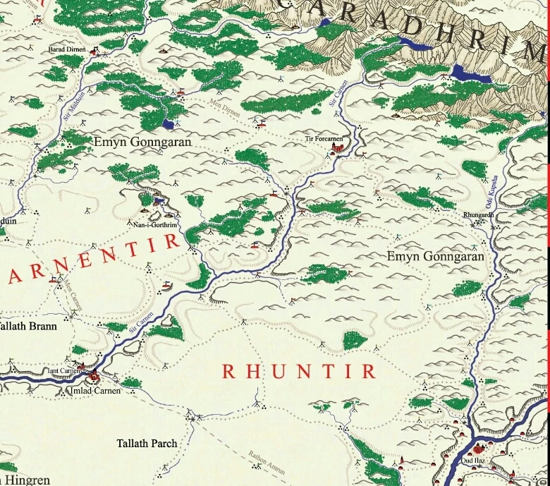
The Emyn Gonngaran (S. ‘Red Stone Hills’),Known to the Haruze as the Ausk Dubat, were a large range of very rugged hills and a vast stretch of lull country lying between the southern Ephel Duath and the great lowland valleys of the lower Harnen and Ode Pezar.They began as foothills of the Ephel Duath on the borders of Ithilien, extending to the lower rivers, joining with the Emyn Imladrim (the southern edge of the highlands til Harondor) to form a distinct expanse of jumbled, scrub-covered hills split by jagged gorges and hundreds of small ravines choked by thorn bushes. Some four hundred miles farther east, the Emyn Gonngaran faded into the less rugged desert country of the Bursk Merag. The Harnen and many of its tributaries bisected the midsection of the hills with the gorges of Kres Lugal. Two roads, the Irit Núrn and the Rak Chelkar ran alongside these rivers to connect Oud Ilaz and Amrûn, south of the Emyn Gonngaran, with passes leading to Núrn and Chelkar, north of the hills. During ihe years of Gondorian influence over Harad, the Harnen served as the eastern boundary for the province of Harondor. Gondor's access to the upper Harnen and the Rak Chelkar was provided by three roads running across the grain of the highlands of Harondor from west to east: the Rath Amrûn, connecting Amon Eithel and Tiras Amrûn across the Aegardh, jumping the gorges of the Malduin and Carnen and working down to Amrûn through the Emyn Imladrim; the Men Dubat, a lesser road that ran along the southern edge of the Emyn Gonngaran to Oud Ilaz and the Men Dirnen, a military road running from Athrad Poros along the foothills of the Ephel Duath, turning down the Ode Tesar to reach Oud Ilaz trom the north.
references[]
- MERP:Southern Gondor - The Land
- Fanmodules:MORDOR GAZETTEER